Cloud Drone Data Management vs. Scattered File Storage: What Works Best for Aerial Imagery?
Why Drone Data Management Matters
Drone operators collect enormous volumes of aerial imagery on every flight. A single survey can produce hundreds of high-resolution photos, video files, and geospatial data. For years, the standard approach was simple: copy everything onto a local hard drive or a shared network folder, maybe label a few folders by date, and call it done. That method works for a handful of flights, but as operations grow and more people need access to the data, scattered file storage quickly becomes a bottleneck. Teams lose files, struggle to find the right version of an orthomosaic, and waste hours manually sorting through folders. An aerial imagery platform designed for drone data offers a more organized alternative. The question is which approach fits your workflow and when you should consider upgrading from ad-hoc storage to a structured system.
Scattered File Storage: The Familiar but Fragile Approach
Storing drone data in ordinary file folders is the default for many small teams and solo pilots. It requires no special software or subscription. You plug in an external drive, drag files into a folder named after the project, and you are done. For occasional flights or very small datasets, this simplicity is hard to beat. There is no learning curve, no upload time, and no dependency on an internet connection. You can hand a drive to a colleague and they can open the files immediately with standard software.
Yet this approach has serious downsides. File names and folder structures are only as consistent as the person creating them. Over time, conventions drift. One person uses "ProjectA_2024-03-01" while another uses "March 2024 - Project A - Final". Searching for a specific image means opening folder after folder. When multiple people need the same data, someone has to copy files onto a shared drive, and soon you have duplicate versions, partial copies, and confusion over which file is the latest orthomosaic. Backups are manual and often incomplete. If a drive fails, you can lose months of work. And sharing data with a client or partner means zipping large folders and sending them via email, FTP, or a file-sharing link with no preview or version control.
Scattered storage is workable when you have a single operator, a small number of projects, and limited need for collaboration. But it does not scale. As soon as you add a second pilot or a client who wants to review images, the cracks show. You spend more time managing files than flying.
Cloud Drone Data Management: Centralized and Purpose-Built
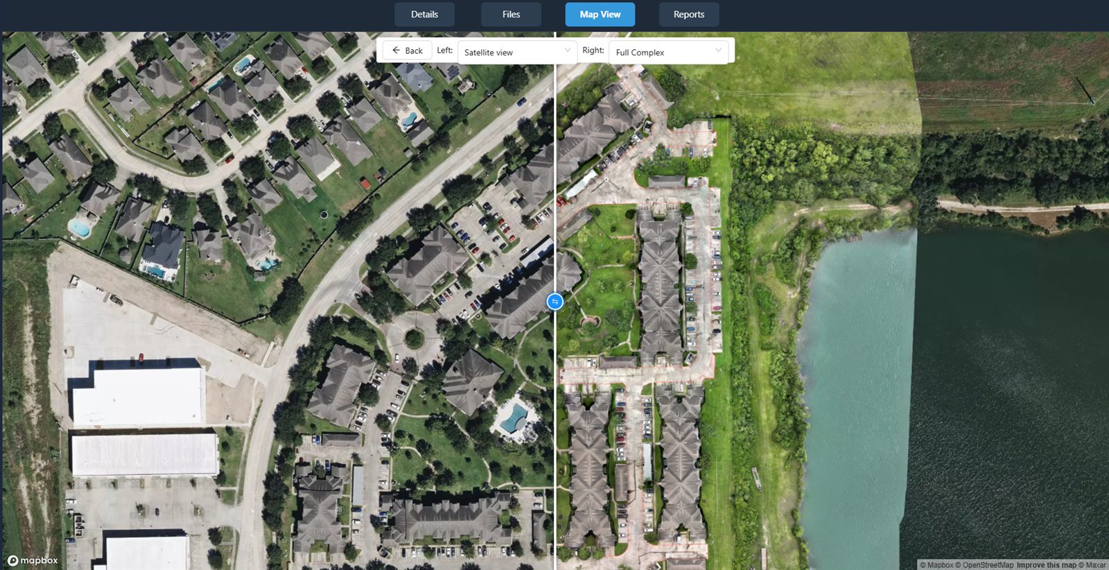
A cloud-based aerial imagery platform is built from the ground up for drone data. Instead of storing raw files in generic folders, the platform ingests images and video, processes them into usable formats like orthomosaics and 3D models, and organizes everything in a searchable library. The data lives in one place, accessible to anyone with permission, from any internet-connected device. This eliminates the folder hunt. You can find an image by project name, date, location, or even by visual thumbnail without opening every file.
Most platforms also handle processing steps that are cumbersome with local storage. They can stitch hundreds of overlapping photos into a seamless orthomosaic, generate elevation models, and align imagery to real-world coordinates. These tasks require substantial computing power and specialized software. Doing them locally ties up your computer for hours. A cloud platform offloads that work to its servers, freeing you to fly more missions while processing runs in the background.
Collaboration becomes straightforward. You can share a project link with a client, who can view the data in a web browser, take measurements, and add comments without downloading anything. No more emailing large files or worrying about version mismatches. The platform also handles backups and redundancy as part of its service. If your laptop dies, your data remains safe and accessible from another device.
When Each Approach Suits Your Workflow
There is no one-size-fits-all answer. The right choice depends on your operation's size, your team's technical comfort, and how often you need to share data. Here are some scenarios to help you decide.
Scattered storage may be enough when:
- You are a solo operator flying fewer than ten projects per year, with datasets that fit on a single external drive.
- You never need to share raw data with clients or colleagues who are not physically present.
- You have a consistent naming system and manually back up your files to a second drive.
- Your clients only want final deliverables like a printed map or a PDF report, not the original images.
- You are comfortable with the risk of data loss from drive failure or accidental deletion.
A cloud drone data management platform makes sense when:
- You have multiple pilots, office staff, or clients who need access to the same data simultaneously.
- You frequently share large datasets over the web and want clients to be able to view, measure, and annotate without downloading.
- You process imagery into orthomosaics, elevation models, or 3D models and want to automate that work.
- You need to keep data organized across dozens or hundreds of projects and find specific images quickly.
- You want automatic backups and the ability to access your data from any device, anywhere.
Many teams start with scattered storage and switch to a platform when the pain of managing files outweighs the cost and learning curve. The transition is not all-or-nothing. You can keep local copies for archival and use the platform for active projects. Over time, you may find that the platform becomes your primary workspace.
What to Look for in a Drone Data Management Solution
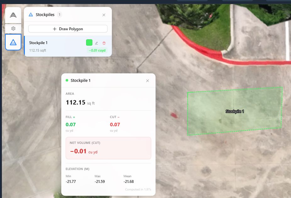
If you are considering moving from scattered files to a structured platform, focus on a few key features. First, ease of upload. The platform should accept common drone file formats and allow you to upload directly from the field via a mobile app or web interface. Second, processing capabilities. Check whether it can generate orthomosaics, point clouds, and elevation models automatically, and whether you can adjust processing settings like ground control points. Third, viewing and measurement tools. A good platform lets you pan, zoom, measure distances and areas, and compare images side by side without any special software. Fourth, sharing and permissions. You should be able to invite clients or colleagues with different access levels and control who can view, edit, or download data. Fifth, integration with your existing tools. Some platforms connect with common GIS software or export data in standard formats like GeoTIFF or LAS.
One example of a service that provides this kind of centralized workflow is National Drone Services. Their platform offers a way to upload, process, organize, visualize, compare, measure, and share drone aerial data, with nationwide turnkey capture. While many providers offer similar capabilities, the key is to find a solution that matches your typical project volume and the technical expertise of your team.
Making the Switch: Practical Considerations
Transitioning from scattered files to a cloud platform does not have to be disruptive. Start by moving your most active or recent projects into the platform. Leave older archives on local drives unless you need regular access. Most platforms allow batch uploads, so you can transfer an entire folder structure at once. Take time to tag projects with consistent metadata: project name, date, location, client, and any notes. This upfront effort pays off later when you search for data.
Be aware of internet upload speeds. Large drone datasets can take hours to upload over a typical residential connection. If you fly in remote areas with poor connectivity, you may need to upload after returning to the office or use a platform that supports offline uploads that sync later. Some teams use a portable hard drive to transfer data from the field to a computer with a fast connection.
Cost is another factor. Cloud platforms typically charge a monthly or annual subscription, sometimes with additional fees for storage or processing time. Compare these costs against the value of the time you spend managing files, the risk of data loss, and the convenience you gain. For many organizations, the subscription is cheaper than the labor hours it replaces.
Finally, evaluate the platform's data export policy. You want to be sure you can download your data in standard formats if you ever decide to switch providers. A good platform makes it easy to export your entire library or selected projects without lock-in. National Drone Services and similar services generally provide these options, but always verify before committing.
Striking the Right Balance
There is no wrong answer between scattered file storage and a dedicated aerial imagery platform. The right choice depends on how many people need the data, how often you process imagery, and how much you value quick access and automatic organization. If you are still managing drone data on a local drive with a handful of folders, and it works, there is no rush to change. But if you find yourself spending more time hunting for files than analyzing them, or if clients are asking for a better way to review your work, a cloud platform can transform your workflow. The key is to choose a solution that fits your current scale and can grow with you as your operation expands.
National Drone Services on social media
 Facebook